
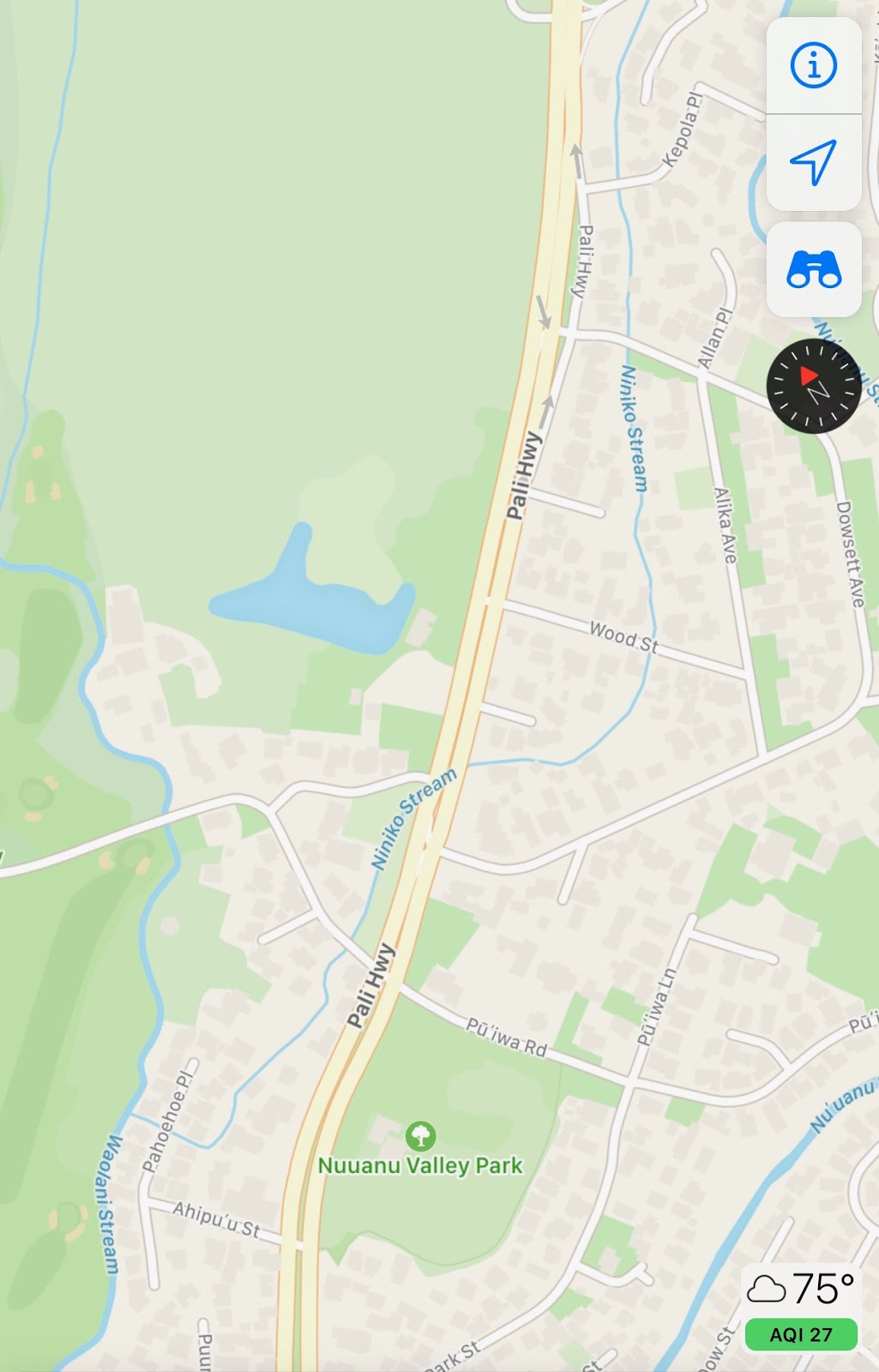
Really. When I saw little Niniko Stream on my map, I expected a little bit of nothing. What kind of stream begins in the middle of a valley. Even in one as lush as Nu‘uanu, what is this waterway that sits in a residential area and is underground in patches along the way south?
Turned out, Niniko is a little gem, one of the prettiest I've seen across Honolulu. But I stopped at International Baptist Church, where the stream rolls into a tunnel and proceeds under Pali Highaway to the ewa side. I never ventured there until yesterday, expecting less. Less flowers. Less access, maybe.
What I found was the massive trees and the chirping of birds that accompanies a healthy stream. But I couldn't see Niniko at first. I walked through some bushes and tried to avoid tripping over vines. I saw a dry bed where a stream clearly once existed, cutting through some old lava rocks. Boulders. What happened to the water? But as I scanned in the makai direction, wow.
It looked like a lo‘i through the branches and leaves. What is a lo‘i doing in someone's back yard?


Strangely beautiful. I got out of the bushes and trees, got back to pavement and saw the pond at its fullest. It's no back yard. It is part of Nichiren Mission of Hawaii, which has been there since 1956. Prior to that, the property — and mansion — was home to Clarence Cooke, son of Charles Montaque Cook, heir to the Castle & Cooke monolith. From the property maps of the time — I found one from 1920 — Cooke helped build nearby Oahu Country Club. But once the Pali Hwy was under construction, he lost his desire to remain there. He sold the place for $1 per square foot, or $80,000, to a Buddhist church that was on School Street.
Update 7/19/20: It appears that the sale of the property had much to do with the city's plan not only to build the highway, but to condemn seven acres of Cooke's property, which stood in the way. The estate that contains the church was a part of the 17-acre expanse which included the Clarence H. Cooke House, or Marks Estate. That is located way up mauka several blocks, on the east side of the Pali Hwy, and quite close to the origin of Niniko Stream. The House is still fronted by a massive, open green space. The city got their land, and Cooke left in '56.
Nichiren has been at the estate, painstakingly and lovingly caring for the pond since. It is actually not taro, but it is a koi and lotus pond. Niniko Stream runs adjacent to the pond on its east border. Water from the stream trickles into the pond through a pumping system.
At the bottom side of the koi pond, water again exists via pump, and rolls downhill back into Niniko Stream. I have to wonder if that water is even more nourishing after koi live in it. The valley was known for an amazing design of terraced lo‘i a century-plus ago. Springs everywhere, not to mention secondary, intermittent waterways in one of the rainiest valleys of Hawaii.
One odd note: The stream has two entry points, it appears. The active waterway is probably Niniko. What is the other one? Or is this a combination of Mo‘ole and Niniko. or just two paths for Niniko. Or maybe the white concrete on the right is just part of the wall and has been broken down over the years.

Doug and Sarah from the church were kind enough to allow this stranger to hang around, ask questions and enjoy the sight close up. Doug pointed to a 1920 map on a site, which has a colorful and excellent page about Nu‘uanu Valley. This map that listed the stream as Mo‘ole, not Niniko, which instantly gripped me. How is this possible when Mo‘ole Stream is a good half-mile or more up the valley. I found a 1920 map (below) on the Pacific Worlds site has Cooke's name on the property site, and again, the stream is listed as Mo‘ole. This is roughly around the time when the reservoirs of Nu‘uanu came into play. This shows the kingdom's hyrdoelectric power site. Map by Monsarrat.

The same terrain today (2020). Mo‘ole is now Niniko.
Here’s the 1920 map from qpublic.com.


Based on these maps, it appears Mo‘ole connected mauka to makai through this part of Nu‘anu. Then Mo‘ole was diverted to the east, leaving a remnant behind that still exists, obviously. More on that below. Also, Niniko Stream is in the books by at least 1978 in an "exhaustive inventory of perennial streams" produced by the Department of the Interior and titled "Stream Channel Modification in Hawaii."


When Cooke sold the property to Nichiren Mission, Pulelehua Way was built along with the new highway. And that is likely when Mo‘ole Stream became covered. However, the reservoirs were quite old by then, so when did Mo‘ole Stream on the east side of Pali Hwy. become Niniko?


Well before that, King Kalakaua had already built out a basin where Reservoir No. 1 stands, just a block or two mauka of Cooke's property. That basin collected water from far up the valley, and was in turn utilized for hydroelectric energy to power Honolulu. Yeah. They never taught us this about King Kalakaua in school.
But the buildout of Reservoirs No. 2 and No. 3 across the way may have led to the change in name of the stream next to Nichiren. I believe Mo‘ole, a sometimes dry stream that can be dangerously loaded during heavy rains, was redirected from west to east, from the ridge to Nu‘uanu Stream on the east side. Reservoir No. 2, which next to Nu‘uanu Pali Road, is well utilized, always flowing as it receives water from Mo‘ole, and more so this current season, from Makuku Stream — which continues through No. 3 located slightly mauka. I visited that connecting waterway last week and was pretty excited to see the stream busy with a nice flow and some active little fishies.
Anyway, because of the theorized re-direction of Mo‘ole, the remnant of the stream is what we have now with little Niniko Stream. So Niniko appears to begin along the back yard of residents of Niniko Place, and right away, it is not a raging force of water. But it still does its job, and as it flows makai, it remains busy as it grows.
I had no idea it would still be fun on the other side of the highway, let alone be a feeder into a beautiful koi pond. Especially when the mauka, east side of Niniko had far surpassed any expectations. On the map, Niniko continues under the Country Club Road, and then does an L-turn west under Pahoehoe St. There is no visible stream there as houses and pavement cover it. I just hope Niniko is visible on the other side of the residential zone, where Oahu Country Club remains, where Niniko converges with Waolani Stream.

According to this random fishing site, Niniko Stream has a few "alternate" names. Among them is Mo‘ole.


The ginourmous trees mark the start of Niniko Stream on the ewa side of Pali Hwy. Where there are singing birds, there are big trees, and usually a stream.


A day later, I returned and had a nice, early evening walk along Country Club Road. The bridge there is hidden in plain sight with its rock walls and lush foliage.

Quite shady and cool there, but signs of imminent danger are built into the side walls. Imagine rainy season and the potential for flooding at this relatively narrow stream. All along Ninole in this residential area that borders Oahu Country Club, the stream is just a few feet from homes. The high wall is on the residential side. The golf course side, natural terrain.


Entering the golf course at Oahu Country Club. It's after hours, basically, just before sundown. A passing shower. I am on the search for the merge between Niniko Stream and (below) Waolani Stream. It didn't happen. The foliage is so thick and wide, there's no way to see it. The merge is located four houses down from the entrance/road. Not visible.


This is where Niniko and Waolani Streams meet, according to maps. But most of the stream is lush and thick. No visibility.


Comments
not too many people care about water, water courses, places, place names, and history. i’ve been trying to find out more ablut Niniko/Moʻole for years as i live in the area.
in the 1920 map, you can see a feautre called “Lake George”, where Waolani and Niniko/Moʻole streams merge. i need to do a map overylay, but i suspect that Pāhoehoe Place is built right over that, and runs below Ahipuʻu, (on the map “Ahipu”).
Niniko/Moʻole stream used to run under the houses on the mauke/hikina (east) side of the street, but was diverted just a few houses makai of the Cooke estate, probably when then area was subdivided for development in the 1950’s. a former resident told me the lower, flat part of Pāhoehoe place used to be a large pond (i got the impression that it was ornamental, but he was remembering it as when he was a child back in the 20’s. My father said the streat was diverted into a culvert turning back towards Waolani, and emerges from the culvert into the top part of the channelized section of Waolani stream. When i was a kid, i had a babysitter who lived on that property, and i would stare at the water coming out under the house for hours.