
(Updated 8/20 with photos of Waialae Nui basin area and bridge.)
I know what “kapakahi”means. Or I thought I did. Since when did it become the name of a stream? Or bridge?
kapakahi — Pukui-Elbert, Haw to Eng / kapa.kahi /,
vs., One-sided, crooked, lopsided, sideways; bent, askew; biased, partial to one side; to show favoritism. Literally,one side.
- Examples:
- Kū kapakahi ka lā ma Waiʻanae (saying), the sun appears lopsided at Waiʻanae [said by the goddess Hiʻiaka while her lover was dallying with someone else, hence said of any unlawful dallying].
Informative. I grew up thinking kapakahi was about something mixed up and messy, out of control. Close, but now I know the exactitude. Mahalo, Mary Kawena Pukui 🙏🏼❤️
I love my phone map, so I dug in and it showed me a Kapakahi Gulch mauka from the bridge. But it was on/in the ridge that splits Waialae Nui. Hmm...
I thought a gulch was large and deep, like Kipapa Gulch in Central Oahu. But it is actually about the terrain, too. And its potentially powerful effect.
gulch
/ɡəlCH/
noun NORTH AMERICAN
- a narrow and steep-sided ravine marking the course of a fast stream.
Definitions from Oxford Languages
From Wikipedia:
Description
In xeric lands, a gulch is a deep V-shaped valley formed by erosion. It may contain a small stream or dry creek bed and is usually larger in size than a gully. Sudden intense rainfall upstream may produce flash floods in the bed of the gulch.
* * *
And that describes quite few valleys in Hawaii. So on the map, Kapakahi Gulch is not drawn with any connection to a stream, but likely where the collection of heavy rainfall produced flash flooding. Prior to residential development, maybe it fed into the stream on the ewa side, listed as “Waialae Stream”. That stream, to me, makes more sense as “Waialae Nui Stream” because the other stream on the east side is the one that leads to the Upper Kapakahi bridge, or stream.
The whole concept of Waialae Nui and Waialae Iki never crossed my mind until recently. Never spent much time in the area at all, so I suppose I never though of the place names. East Honolulu is a mix of historic names that are commonly used today, like Kalama Valley, and more modern-ish names like Hawaii Kai, Mariner’s Ridge and semi-historical names like Kahala.
Waialae Nui is where a couple of friends live. That ewa-side stream rolls through the side of Wilson District Park, one block from Kahala Mall. The east-side stream, Waialae Iki or Upper Kapakahi, is close by as the two head toward Waialae Golf Course. In fact, when the two streams dive under Malia Street, Star of the Sea School is all that separates them.
I wonder if Kapakahi Gulch actually fed a third stream in between these two current waterways. Construction and pavement have literally made streams and natural springs disappear all over Honolulu. And if a third stream — a tiny bit similar to Niniko Stream in Nu’uanu — never existed, then where does the water go when the Gulch is innudated? The threat of Hurricane Douglas yesterday had me intrigued.
There are many streams that take the name of nearby ridges and places, so it’s quite possible that Kapakahi Stream simply received that overflow back in the days when this was a rural area. I didn’t see a lot of small ditches that feed either stream, but they’re probably all over. Or maybe Kapakahi Gulch is already piped up and connected to either stream. In Nu’uanu, King Kalākaua had a major wet spot deep in the valley pipelined to the original reservoir (No. 1) for hydroelectric purposes more than a century ago.
Anyway, a random trip to sightsee Waialae’s streams on a quiet Sunday afternoon while the islands were under hurricane watch turned out to be interesting. It doesn’t often rain heavily in East Honolulu, and the channelization of waterways is always a hallmark of solid flood control design. It ain’t as pretty as a natural stream, but aesthetically, these streams are dry most of the time anyway.
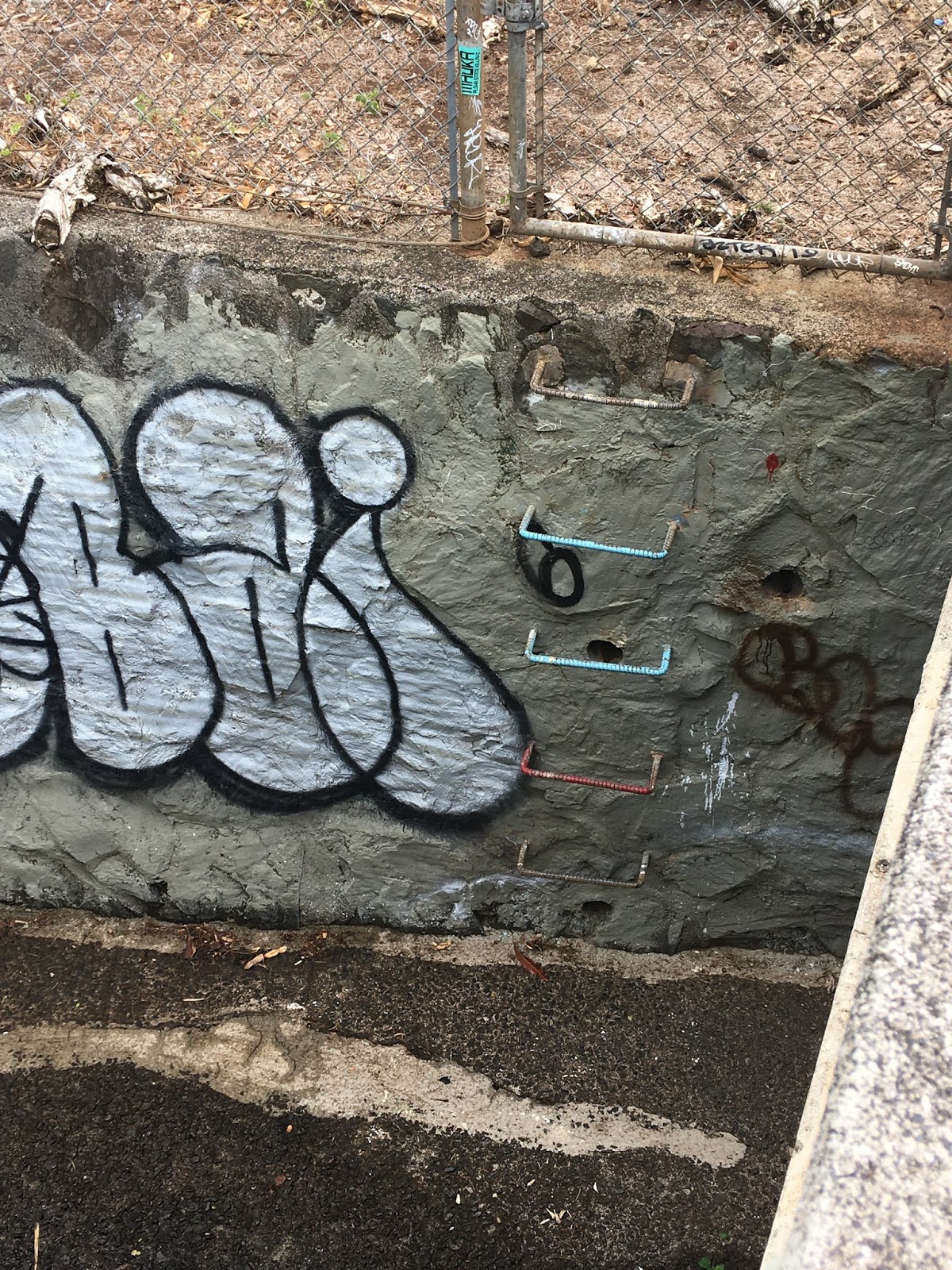
Unlike Nu’uanu and its natural streams, forests and waterfalls, Waialae is a microcosm of life in the post-development era. Not a single square foot is wasted if habitable. That’s why it was fun to see the stream tuck under the freeway. It is a street artist’s haven there, something I had never seen or known. The entry way to the golf course is visible, too.
So I’ll dig more to see if there really were/are Waialae Nui and Waialae Iki streams, whether the east-side one is actually Kapakahi Stream. I’d bet on the latter.
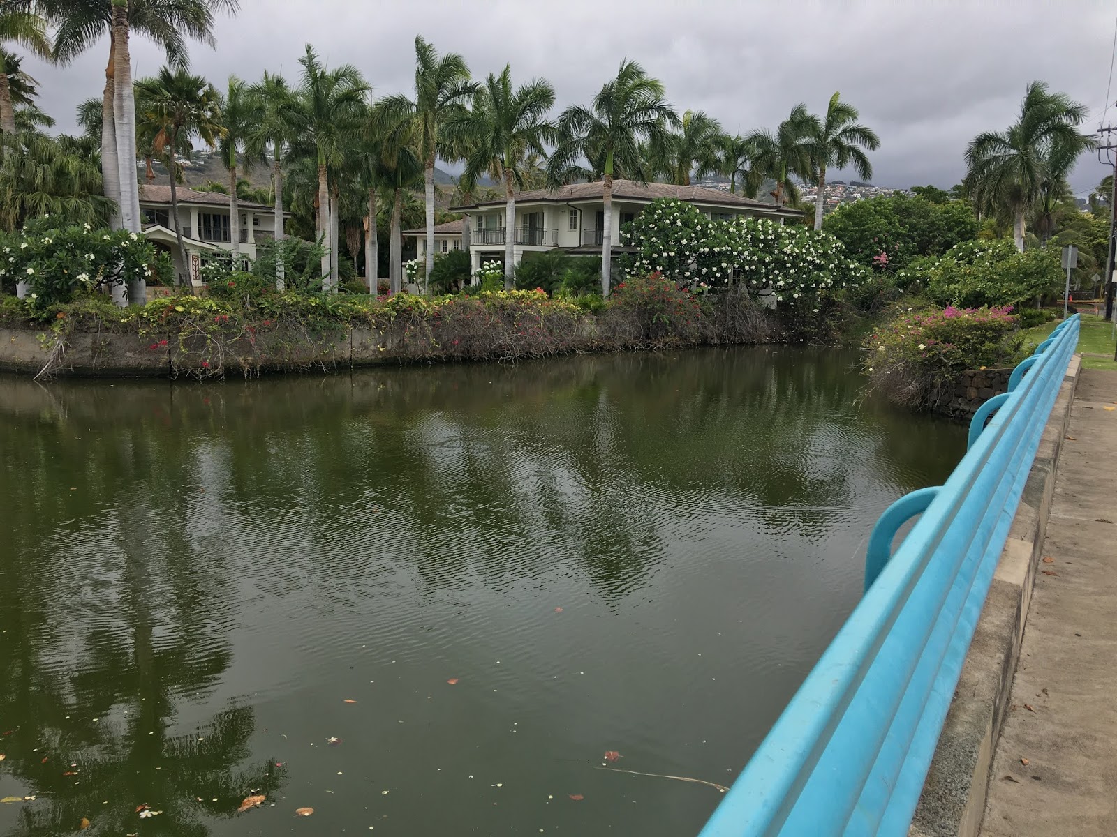
I don’t have access to the golf course, so I went right to Kahala Avenue, where the joined streams have a beautiful presence. It’s hard to expect a result like this, so wide, so serene, after seeing the two streams barely churning out flow even on a hurricane-watch day.
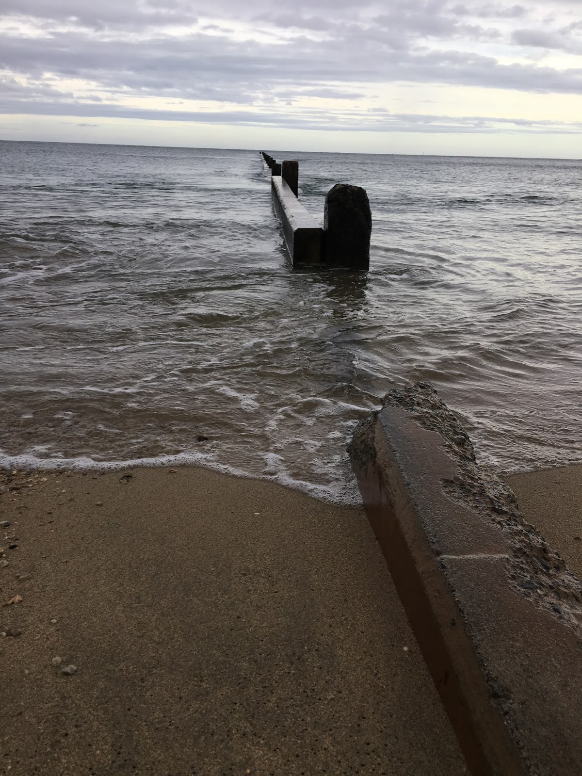
At Waialae Beach Park, I didn’t notice much wildlife. Barely any activity in the water, which appears to be clean. No visible pollution. The park and beach were fairly empty. The perfect time and place to lean back and enjoy the sounds and scenery. At nearby Kahala Hotel and Resort, the view from above must be spectacular. At the nearby park, it’s easier to hear the waves and lose track of time.
Epilogue: A Google search turned up precisely one match for "Upper Kapakahi."
http://hartdocs.honolulu.gov/docushare/dsweb/Get/Rendition-2072/index.htm
It's an apparently old, old site that is tough to load up. "Kapakahi Stream" is mentioned, no shock. Was there always a Waialae Nui, or was this area in general known as Kapakahi? That would be funny.
"Kapakahi Stream" has 94 matches. Most, if not all, are for a Kapakahi Stream in Waipahu that feeds Pearl Harbor. It is part of the Waikele ahupuaa. Hmm.
The state's DNLR Flood Hazard Assessment Tool locates a Kapakahi Springs on Oahu, on the Windward side of the Koolau Mountain Range in the general area of Maunawili.
http://gis.hawaiinfip.org/FHAT/
On the assessment tool, Kapakahi Stream shows up as the same one that originates in Waikele. However, "Upper Kapakahi" shows up as a location in Kohala district of the Big Island.
The mystery will be solved. I'm in no rush to find answers. Waialae turned out to be a lot more interesting — I'd expected dry beds everywhere along the way — than expected.
Kapakahi Gulch/Stream Boulder Basin
http://hartdocs.honolulu.gov/docushare/dsweb/Get/Rendition-2072/index.htm
It's an apparently old, old site that is tough to load up. "Kapakahi Stream" is mentioned, no shock. Was there always a Waialae Nui, or was this area in general known as Kapakahi? That would be funny.
"Kapakahi Stream" has 94 matches. Most, if not all, are for a Kapakahi Stream in Waipahu that feeds Pearl Harbor. It is part of the Waikele ahupuaa. Hmm.
The state's DNLR Flood Hazard Assessment Tool locates a Kapakahi Springs on Oahu, on the Windward side of the Koolau Mountain Range in the general area of Maunawili.
http://gis.hawaiinfip.org/FHAT/
On the assessment tool, Kapakahi Stream shows up as the same one that originates in Waikele. However, "Upper Kapakahi" shows up as a location in Kohala district of the Big Island.
The mystery will be solved. I'm in no rush to find answers. Waialae turned out to be a lot more interesting — I'd expected dry beds everywhere along the way — than expected.
####
Kapakahi Gulch/Stream Boulder Basin
The back of the roadways next to the ridge, at the top of Ainakoa Ave.


Ainakoa Avenue leads into the back of the residential zone, where there is an interesting water-break type barrier made of concrete. The boulders embedded in the ramp are a visually interesting touch, kind of like M&M chocolate chip cookies. Looking beyond into the valley, it's not hard to imagine that a once-in-a-century downpour can really mess this area up, so the funnel effect of the barrier or berm is a must. I wonder how often people go hiking back here. It's intriguing, even though there isn't a consistent waterfall like the terrain in Palolo, Manoa and Nu‘uanu Valleys.
On the west side, Waialae Nui Stream intersects with Kilauea Avenue, which has to be one of the most interesting paths I've seen. Kilauea Avenue goes from the side of Diamond Head, bringing athletes to Kilauea District Park and gym, Kaimuki Middle School and Kapiolani Community College, through Waialae-Kahala, and straight mauka. This area isn't quite a forest, but how many roads in America take you from a half-mile of the ocean to the mountains?
The stream wall here is reinforced, probably to provide support for the properties. Our geology professors at UH always said that erosion is a big issue in Hawaii, always will be.
Update: Aug. 20, 2020. I'd forgotten that I didn't get any shots of the basin at Waialae Nui, so here. It's an interesting basin area, hard to see from street level and, in fact, unlike other basins in East Honolulu, this street runs along the waterway and further mauka behind it. There are boulders on surface level ground behind a fence that act as a sorta boulder basin. This is a mix of makai and mauka view, the Waialae Nui basin area and down makai, long before it connects with Kapakahi Stream.
Here's the aerial view of the basin via Google Maps.


* * *
And this is what I posted originally, below to the end of this post.


The bush in the photo above is similar to what I've seen in the water at Nu‘uanu Reservoir No. 2. No matter what the design is, plants in Hawaii will grow in any situation. My guess is this stream, like Manoa-Palolo Drainage Canal, has to be cleared at least once a year. That's a lotta work at a lotta streams. Without that, major flooding danger.


Waialae Nui Stream continues along the ridge (Waialae Nui Ridge), out of sight from the street, behind a row of homes. It runs under Hiikala Place.
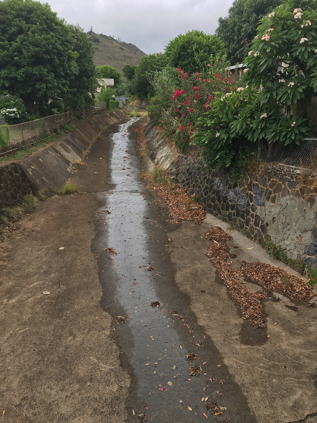
From there, the stream becomes the borderline for Wilson Park. A lot of rock-wall work here, and with the familiar V-shaped channel. Waialae Nui Stream meets Malia Street, which also borders Wilson Park.


Here's Kapakahi Stream, the waterway on the east side, at Malia Street, just a short walk from Waialae Nui Stream on the west. Star of the Sea borders Kapakahi Stream.


Two blocks makai, Kapakahi Stream goes below Aliikoa Street, just before the entrance to Star of the Sea Church. This is where the "Upper Kapakahi" signage got me curious.


So it is less than a mile from the gulch to this bridge. I'd love to see the gulch and whether there are pipes diverting heavy rainwater to either stream. If it was a third stream that connected to the current channelized version, where was it? If that theory is correct (doubt it), it would make some sense because a lot of waterways tended to flow to the right, at least in the Manoa/Moiliili/Palolo merge before development.
From Aliikoa Street, Kapakahi Stream ducks under Kalanianaole Highway toward the golf course. Not much to see. However, just 50 yards away, Waialae Nui Stream has a massive space under the freeway. It is here, for the first time on this journey, I see the name "Waialae Nui" attached to this stream. So I'm sticking with that. It just makes geographical sense, regardless of what my phone map tells me. (And it has been wrong before.) So, which came first, the stream bridge or the freeway? Maybe the stream bridge was rebuilt when the freeway came along in the 1960s.


*** Update 8/3/20
It took a topography view to get the literal connection. I hadn't checked the topo site in a long time. Too long. But there it is. The gulch on my phone map appeared to be a single spot, which was confusing. On the topo map, Kapakahi Gulch extends all the way to the Koolaus, which makes perfect sense. A gulch isn't a 'V' shape from a sky view. it is the shape of the area from the ground view looking at the Koolaus. And there on the topo map is the extended reach of Waialae Nui 'Gulch.' Suddenly, it all makes wonderful sense. Reminds me of Mo‘ole Stream in Nu‘uanu, which extends from way up.

Waialae Nui Gulch and Kapakahi Gulch. Waianae Nui Stream and Kapakahi Stream. Simple. Just needed a more detailed map. The topo map reminds of what we had at Ala Wai Elementary School. It was two-dimensional. You could touch the elevated parts of Oahu. Incredible tool.
South shore.

The bridge at the freeway is open to pedestrians on the mauka side, but difficult on the makai side of the road going west, so it's no surprise a lot of people like me haven't seen this space before. It's fun to look at, but the end of the merged streams is a nice spot to finish. Kahala Ave. and Waialae Beach Park is a place to actually hang out at. For as little or as long as it takes to decompress.


Comments